For most Americans, GPS is something they rely on every day. It helps drivers navigate unfamiliar roads, allows airlines to fly efficient routes, synchronizes banking transactions, and keeps emergency responders moving quickly.
But GPS has one important weakness.
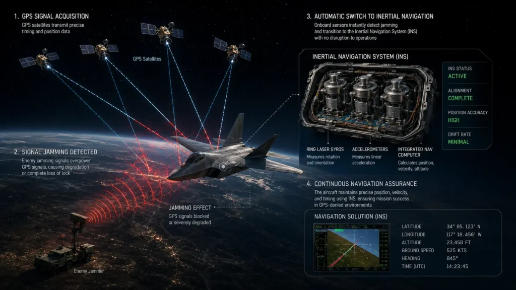
The signals sent by navigation satellites are incredibly weak by the time they reach Earth. A relatively small electronic jammer or a sophisticated spoofing attack can interfere with those signals, causing navigation systems to fail or display incorrect positions.
Military conflicts in recent years have shown just how vulnerable satellite navigation can be. Reports from Eastern Europe and the Middle East have documented repeated GPS jamming incidents affecting aircraft, ships, and even commercial flights.
So what happens if GPS becomes unavailable?
The answer is that the United States has spent years developing multiple backup navigation systems designed to keep critical operations running even when satellite signals cannot be trusted.
Why GPS Can Be Disrupted
The American Global Positioning System consists of more than 30 operational satellites orbiting approximately 20,200 kilometers above Earth.
Each satellite continuously broadcasts timing signals.
Your smartphone or navigation device calculates its position by measuring tiny differences in the arrival time of signals from multiple satellites.
The problem is that these signals are extraordinarily weak.
A portable jammer transmitting only a small amount of power can overwhelm legitimate GPS signals nearby.
Even more concerning are spoofing attacks, where attackers transmit fake GPS signals that appear authentic, causing receivers to calculate an incorrect location rather than losing navigation completely.
The Military Does Not Depend on GPS Alone
Contrary to popular belief, the U.S. military does not rely exclusively on satellites.
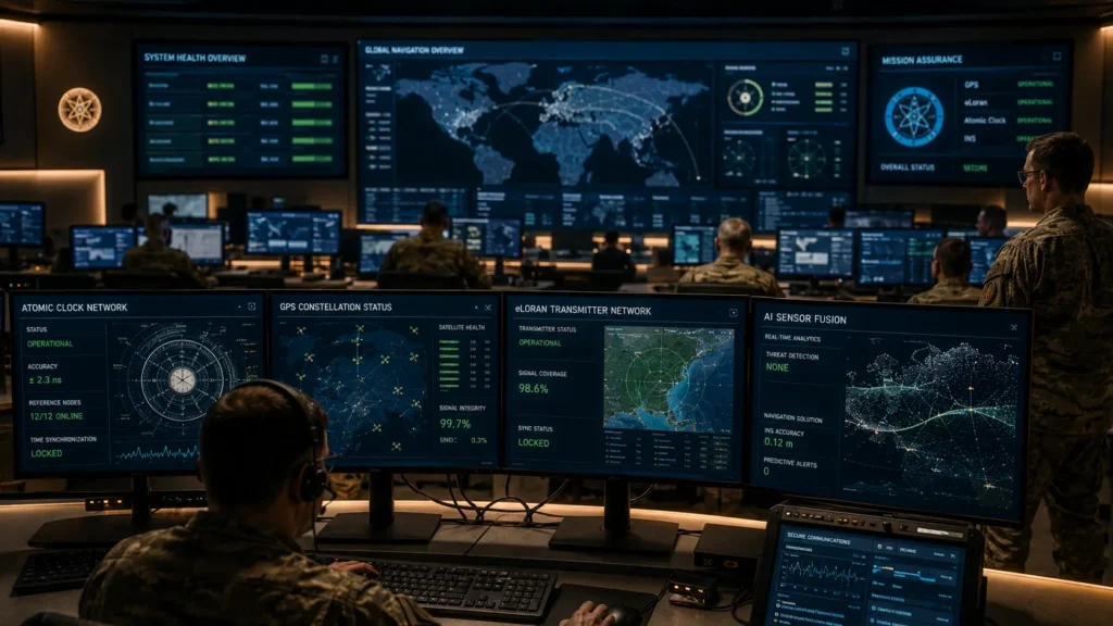
Modern aircraft, submarines, missiles, and naval vessels combine GPS with several independent navigation methods.
This layered approach ensures that losing one system does not immediately cripple operations.
Navigation experts call this resilient positioning, navigation, and timing, often abbreviated as PNT.
Instead of trusting a single source, multiple technologies continuously verify one another.
Inertial Navigation Keeps Moving Without Satellites
One of the most important backup systems is the Inertial Navigation System or INS.
Rather than listening to satellites, INS measures motion directly using extremely precise accelerometers and gyroscopes.
Once the starting location is known, the system continuously calculates:
- Speed
- Direction
- Rotation
- Distance traveled
Modern fighter aircraft such as the F 35, strategic bombers, naval vessels, and submarines all rely heavily on inertial navigation.
Unlike GPS, an inertial system cannot be jammed because it receives no outside signals.
Its only limitation is that tiny measurement errors gradually accumulate over long distances, making occasional corrections desirable.
Atomic Clocks Quietly Keep Everything Synchronized
GPS is fundamentally a timing system.
Every satellite carries highly accurate atomic clocks.
When GPS becomes unreliable, maintaining precise timing remains essential for communications, radar, power grids, banking, and military networks.
The United States uses multiple independent timing sources, including local atomic clocks and specialized synchronization systems, to maintain critical infrastructure if satellite timing becomes unavailable.
Without accurate timing, modern digital networks would quickly experience serious problems.
The Return of eLoran
Another technology attracting renewed attention is eLoran.
Unlike GPS satellites in space, eLoran uses powerful ground based radio transmitters.
Because these transmitters operate at much higher power than GPS satellites, they are far more difficult to jam across large areas.
Several countries continue investing in eLoran as a resilient backup navigation system for aviation, shipping, and national infrastructure.
Security experts have repeatedly identified eLoran as one of the strongest complements to satellite navigation.
Terrain Matching Still Works Without GPS
Military aircraft and cruise missiles can also navigate using the terrain itself.
Systems known as Terrain Contour Matching, often called TERCOM, compare radar measurements with detailed digital maps stored onboard.
If GPS disappears, the aircraft can still determine its approximate position by recognizing mountains, valleys, coastlines, and other geographic features.
This technology has been refined over decades and remains valuable for long range navigation.
Modern Aircraft Compare Multiple Sensor
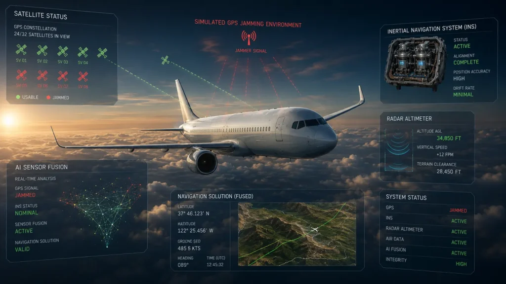
Commercial and military aircraft increasingly use sensor fusion.
Instead of trusting one navigation source, onboard computers compare information from:
- GPS
- Inertial navigation
- Air data sensors
- Radar altimeters
- Radio navigation beacons
If one sensor begins reporting impossible information, the system can detect inconsistencies and reduce reliance on that source.
This dramatically improves resilience against both equipment failures and electronic attacks.
Artificial Intelligence Is Becoming Part of Navigation
Researchers are now exploring how Artificial Intelligence can strengthen navigation during GPS disruption.
AI algorithms can analyze enormous amounts of sensor information simultaneously, identifying abnormal GPS behavior within seconds.
Machine learning also helps distinguish genuine satellite signals from spoofed transmissions by recognizing subtle patterns invisible to conventional software.
While human operators remain responsible for critical decisions, AI is becoming an increasingly valuable assistant in electronic warfare environments.
Why This Matters Beyond the Military
Many people assume GPS disruption affects only fighter jets.
In reality, modern society depends heavily on precise positioning and timing.
GPS supports:
- Emergency services
- Air traffic management
- Maritime shipping
- Mobile phone networks
- Financial trading
- Electrical power grids
- Agriculture
- Construction equipment
A widespread GPS outage could affect far more than navigation apps.
That is why governments around the world continue investing in resilient navigation technologies.
The Bottom Line
Satellite navigation transformed the modern world, but it was never designed to operate alone forever. As GPS jamming and spoofing become more common, the United States continues strengthening its navigation resilience through Inertial Navigation Systems, atomic clocks, eLoran, terrain matching, and advanced AI powered sensor fusion.
Most Americans will never notice these systems because they operate silently behind the scenes. Yet during a crisis, they could become the invisible technologies that keep aircraft flying, ships navigating, emergency responders communicating, and critical infrastructure functioning when GPS signals can no longer be trusted.
Read Also
➡️ How Undersea Internet Cables Carry 99 Percent of Global Data
https://aiwalanews.com/how-undersea-internet-cables-carry-99-of-global-data/
➡️ How a Website Loads in Another Country in Under 1 Second The Hidden Network Behind It
https://aiwalanews.com/how-a-website-loads-in-another-country-in-under-1-second-the-hidden-network-behind-it/
© AiwalaNews | Global Tech & Privacy Edition | April 2026
